The Big Map began in late 2003 as a blank slate to fill in. Over time, "big map" became an intransitive verb, as in "we'll go big map in Queens this weekend." Eventually it evolved into a transitive verb where anything and everything could be "big mapped". We big mapped 5th Avenue in Sunset Park, for example. We also big mapped discarded christmas trees. We've even big mapped the laundromat down the street.
Julian Dibbell wrote about the Big Map in the Village Voice -- "Shuttered: Who will remember all the crappy pizza joints fading into NYC history?" (August 31, 2005).
The Not For Tourists website featured the Big Map in a Radar listing (July 26, 2007)
Big Map Key
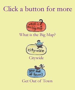
There is a main page for each borough that features a clickable map which in turn takes you to individual neighborhoods and/or geographic sections of each borough.

The Explore button is the shortcut to the entire list of
individual pages for each borough.
![]()
The Feed button takes you to food and dining pages for
each borough, including menus from places we've eaten at.

The Citywide button features pages and/or
things that are not restricted to a particular borough.

Finally, the Get Out of Town button takes
you to that which exists beyond the five boroughs.
How To Big Map YouTube Video
Big Map Blog
You can keep track of Big Map additions via the Big Map Blog! You can also subscribe to the feed . . .
A Word About The Photos
All the photos on the Big Map were taken by Scott or Jennifer -- part of the "concept," such as there is one, is that we actually visited these places ourselves and explored them firsthand. (Since we don't post other people's pictures, this also means that we're unable to accept images for submission, though we're happy to include links to other such sites -- feel free to pass them along!)
Yes, we hold the rights to all the images on the Big Map -- if you're interested in using them, feel free to contact us. BATC photos have appeared in newspapers, magazines, textbooks, various websites and even the cover of a novel. Here are our rates:
High-resolution for personal use: $35 per image.
High-resolution for print use (inside publication, one-time/non-exclusive): $70 per image.
High-resolution for print use (cover): Contact us at info <at> bridgeandtunnelclub.com
You can also pay us through PayPal -- see our page here -- just send an email with details about your request to "info <at> bridgeandtunnelclub.com" (please contact us before making a payment to ensure we have what you're looking for).
If you're looking for a particular image, don't hesitate to ask us -- we may be able to help you find what you're looking for.
If you want to repost a low-resolution image to your website, feel free -- just credit "bridgeandtunnelclub.com" and include a link to the page on which you found the image. E-mail us if you think about it -- it's fun to see how the images are used. Please don't repost images without attribution (that's all we want to have to say about that).
Note: Due to bandwidth considerations, we are unable to allow outside sites to link directly to images on this site.
Finally, if you have a New York City-related interest and would like to see a particular street or place, consider the Big Map Adopt-A-Street Initiative -- for $150 we'll be happy to Big Map a street or place of your choice and provide you with a CD of high-resolution images. Contact us at "info <at> bridgeandtunnelclub.com" for details!
Contact Us!
Email us at "info <at> bridgeandtunnelclub.com". We'd love to hear
from you to tell us what you think, give us suggestions or suggest links
to add, or inquire about images we've taken.